Don’t miss this sensational travel narrative featuring Rosemary J. Brown, a UK-Canadian-American journalist following the swift footsteps of pioneering journalist Nellie Bly who raced around the world in 1889 to beat the 80-day record of a fictional character.
Travel
Are Railways in Peril?
National Rail Networks :: A Look Back in Time
The world’s first national rail networks were constructed in Britain, with the first inter-city line connecting the industrial midland city Manchester with the port of Liverpool in 1830.
So, are you wondering, which country forged a national rail network next? France? Sweden, the United States?
It was Egypt. The Egyptian rail system connected ports on the Indian Ocean to the Mediterranean Sea until the Suez Canal was opened in 1869. Egypt’s rolling stock is still on track. A recent issue of Future Rail magazine reports on Egypt’s recent purchase of 1,300 new carriages.

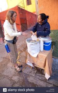
Pedestrians cross tracks at Ramses Station platform.

Street vendor near Ramses Station

All Images byt L. Peat O’Neil

Train in Ramses Station, Cairo.
U.S.A.
In the 21st century some countries like the United States of America are not keeping up a commitment to passenger rail systems.
That’s a shame because rail travel offers faster, more efficient and ecologically favorable long distance travel than commercial airlines or private vehicles. Assuming, of course, the nation-state or region maintains and supports its railway systems.
A close look at an inventory of Amtrak rolling stock looks like an old used carriage auction block. Check out the fancy Amtrak advertising videos promising sleek, fast locomotives in the northeast corridor of the country, the most reliable profit center. Don’t wait in line or online for a ticket because it’s fantasy at this point. Why aren’t the U.S. leaders embarrassed by their poor showing compared to the lightning speed trains of Japan, France, Germany and other European countries?
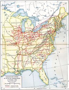
Back in the mists of time, the northern states of the U.S. had established a robust network of rail lines that connected with existing waterway transport and ports before the American Civil War. The southern states also built railways, but the lines dead-headed inland rather than featuring radiating lines that used hubs to interconnect with other railways. The absence of a connected rail network in the south was a factor in defeat.
President Abraham Lincoln signed the Pacific Railway Act into law on July 1, 1862. This progressive action authorized construction of the Transcontinental Railroad. American continental railroads, built by immigrant laborers, usually under cruel and dangerous conditions, were instrumental in opening the western wilderness to travel and trade.
FRANCE
I’ve spent more time and kilometers riding the SNCF railway system in France than any other country. My first rail trip there was in 1966 on the boat-train from Calais (or was it Boulogne?) to Paris. The wider-gauge British trains left passengers at the ferry dock and after the Channel crossing, you’d walk to the French carriages for outward bound destinations. In the past I would ink my train travel routes on a map of France but the lines crossed and recrossed over the years to the point of obliterating the journeys and connections.

France built short rail lines to serve the mining industry. Agricultural communities resisted rail development arguing it would infringe on France’s well-organized transport network of canals and other waterways. Construction of long distance rail systems for commercial and consumer use started after 1842 with a network that could move goods for long distances overland.
RUSSIA
Russia, with distances far greater than the U.S., opened a single railway line from Moscow to St. Petersburg in 1851. With more land distance than the U.S. to cover, and few or no western and southern ports, Russia understood the value of connecting the capital and to ports in the Far East. Russia opened the Trans-Siberian Railway in 1916, though portions of the railway were functioning as early as 1903.
MEXICO
My experience with Mexico’s Railway Network is limited. During the early 1980’s, possibly 1981, my friend Don Tito and I boarded the Mexican railway by taking a Greyhound or Trailways bus from San Diego to El Centro, California and walking across the frontier to a train station in Mexico. I should consult a travel diary from that year to report the distances and ticket cost. I do not recall seeing a border wall at that time. The Pacific and Southwest Railway Museum in Campo, California owns carriages and locomotives of the San Diego and Arizona Railway that resemble the historic rolling stock we rode south through Mexico in 1981.
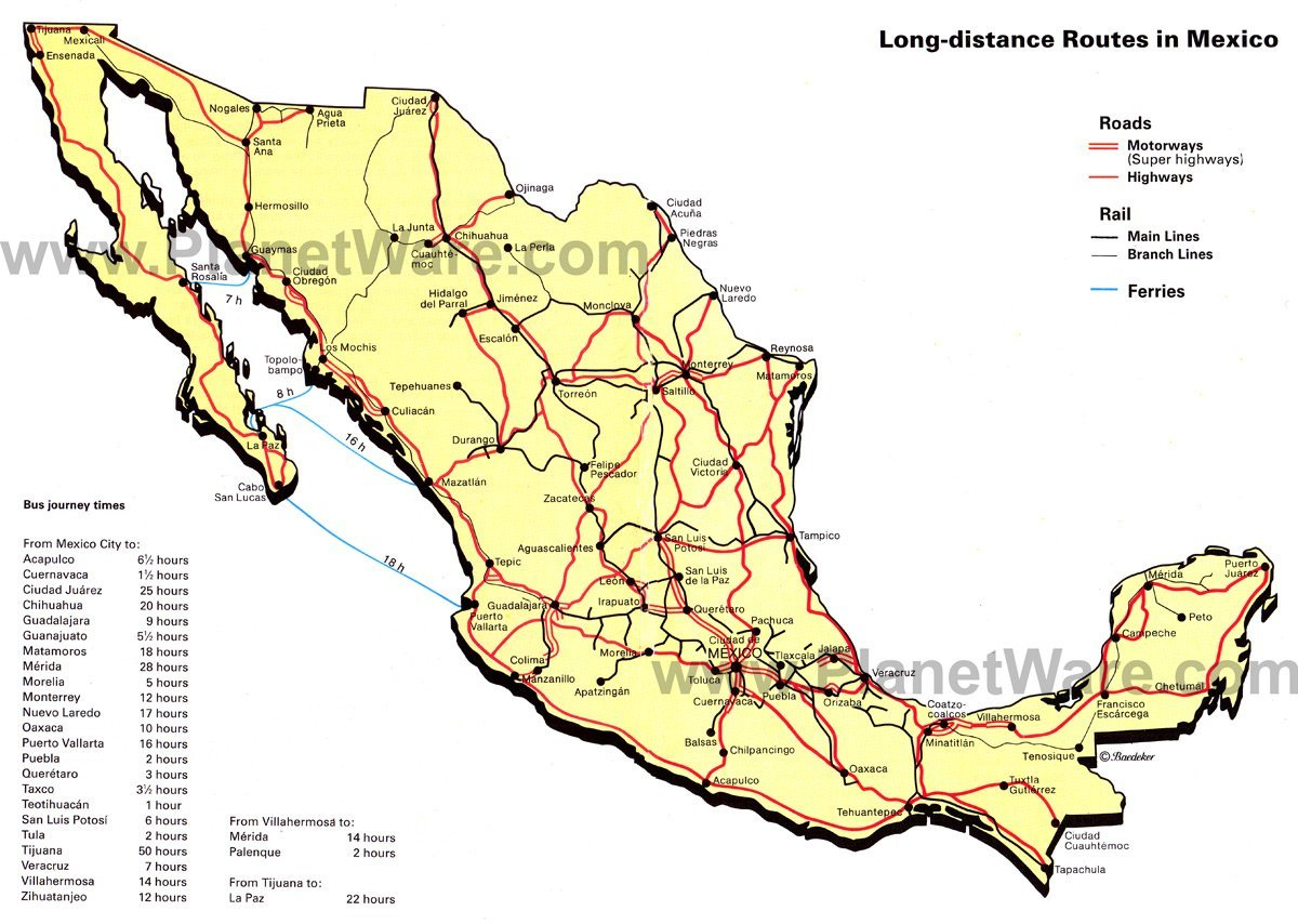
We boarded the Mexican long distance train at a town just steps across the border that took us all the way south to Mazatlan, a gritty seaport opposite the tip of Baja. I do not need to see again. The train ride took two days and nights. Or maybe it just seemed that long. It slowed to a long halt at towns so locals boarded to sell tamales, soft drinks and chiclets out of plastic buckets lined with heated towels to keep the food warm.
Decades later, I lived in Mexico City and wanted to explore the country by train, but during the 1990s, the government had consolidated or terminated most passenger rail systems. Apart from a couple of tourist trains that run limited, scenic routes and a commuter rail system serving the capital city, Mexico’s passenger rail service is a distant memory.
Occasionally, proposals arise to create new passenger rail lines or high-speed rail links between major cities. But proposals are not reality. Until some future date, the inter-city express bus service is adequate, sometimes stellar, but environmentally inefficient.
Ride on, rail enthusiasts!
No White Food
Check our my food blog sometime NoWhiteFood…


The Gastronomica Reader Univ of California Press, 2010.


Muscat du Provence pumpkin vine. 2012


Greenbriar River Bike Trail, West Virginia
Greenbriar River, West Virginia

Cruise along the Greenbriar River Bike Trail and you ride the roadbed of steel rails that no longer exist. Building bike trails on railway beds creates an easy gradient for cyclists, with smooth climbs, easy descents.
The Greenbriar River Trail runs beside the river of the same name for a stretch of 77 miles (124 km) from the settlement of Cass to North Caldwell. One hundred years ago the towns along this railway line were active, the communities thriving, or even bustling fueled with enterprising immigrants from faraway countries and newly or almost-free slaves from the nearby Southern states. Proclamations and edicts such as the end of slavery in the U.S. may have been issued, but the reality of freedom would need decades for real effect. All along the river, people made a living harvesting local resources for those who owned land — cutting trees, mining coal and grinding corn on water mills. And the resources rolled on the river or the railways to markets in other places.
Imagine what an amazing network would exist if every decommissioned stretch of railway in North America was converted to a bike trail! We could bike safely across the continent, easy peasy!
Don’t forget to wear blaze orange or hot pink jackets or vests during hunting seasons in West Virginia. When I rode this trail a stretch of months ago, I could hear hunters taking pot shots in the woods. Did they know the bike trail exists?
Wikipedia states “the Greenbrier is the longest untamed (unblocked) river left in the Eastern U.S.” which is a sad thing to learn. Culverts, dams, spills, canals, diversions steal the vitality of the other long rivers in the Eastern U.S.
Toronto for TIFF and Fashion

The last time I enjoyed the brisk bright nightlife district in Toronto, I was writing a story for Washington Flyer, an airport customer magazine.
On this recent trip, my visit overlapped the opening week of TIFF — Toronto International Film Festival — a bit like Cannes without the huff and Hollywood.
![]() We join the ecelictic mix of late night party mammals at the top of Mr. Trump‘s hotel where the cocktail napkins are emblazoned with a large $ symbol. The barman was studying for an exam, we guessed, since he was slow to loosen up and was consulting a book.
We join the ecelictic mix of late night party mammals at the top of Mr. Trump‘s hotel where the cocktail napkins are emblazoned with a large $ symbol. The barman was studying for an exam, we guessed, since he was slow to loosen up and was consulting a book.
In the elevator going down, the vapid girl-star from the vampire flicks was nosing her thumbs into a crack berry while an assistant in a too-tight denim jacket worked media appointments on her mobile. The big ‘ole body guard was Russian, Serb or Tra-jikastan.
Over at Four Seasons bar, the vibe was easier, but we didn’t like seeing the drink maker fish olives from the jar with his fingers. Please!
In front of TIFF headquarters, people with and without tickets milled around in amoebic clumps, seeing and being the scene. On another day I went to Queen St. East (way East) to Jac Flash to buy poppy strewn skinny jeans. 
At KitKat/Club Lucky the mood is casual and off-hand chic. Downstairs is a familiar bar; upstairs explosed brick walls, red check table cloths, cigars and single malt. A tuxedo-wearing tenor from the London cast of Phantom might serenade the birthday girl at his table to exhuberant applause from the whole room gets into the act. The scene for cigars and single malt.
The Old Front St. neighborhood of downtown Toronto centers on St. Lawrence Market. The two buildings — one 19th century, one modern — are crammed with food vendors, purveyors of gourmet bottled goods and the foodie crowd angling in for a free taste. Back in the day the market was a lot more earthy and real with Italian sons of butchers hollering out to visitors, ‘buy our sausage, not from the next guy’.
Approach the Cathedral Church of St. James, 106 King St. E. from the south through the Market Square courtyard and sculpture garden for a memorable prospect of the 306 foot tower and spire, the tallest in North America after St. Patrick’s in New York City. 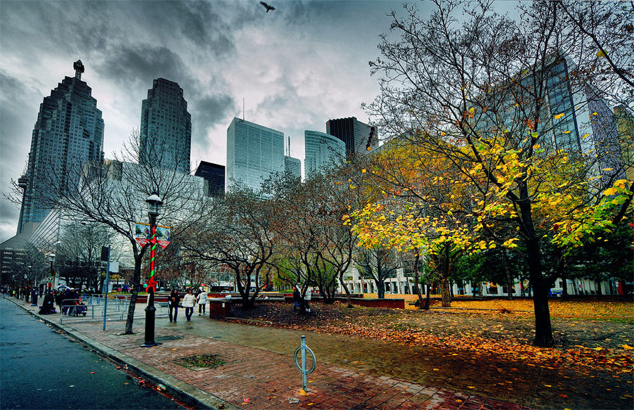
End the day at the ornate, opulent and sensually engaging Winter Garden. It’s all that a theatre should be. Colored lights hang from the ceiling, real and artificial branches suspended on high create the effect of stepping into a midsummer’s night dream extending from the stage to the back of the house. I saw the interior of this theatre with a CBC radio reporter back in the day when dedicated preservation groups worked to save it from the developer’s wrecking ball. So glad it was saved.
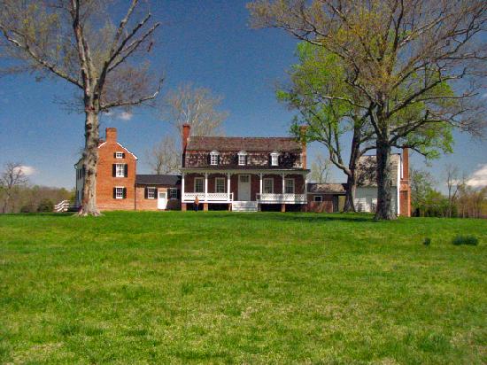
Port Tobacco, Maryland
Port Tobacco was not on the water when I visited.
Prior to the American Revolution, this Maryland hamlet barely an hour’s drive south-east of Washington, DC was the second largest seaport in the American colonies. Ships anchored to be loaded with barrels of tobacco bound for Europe and the rest of the world. Port Tobacco was on the world map.
In recent decades the nearest water to Port Tobacco was a marshy stretch where archeologists are examining residue for shoe buckles, clay pipes and artifacts from the original settlers in this area, Algonquian-speaking tribal peoples. Hardly enough water near Port Tobacco to support a kayak hull, let alone a blue water schooner. But that’s changing, thanks to community involvement in river restoration efforts and the Port Tobacco River Conservancy
The Catholics arrived in 1658, the Episcopals next. One hundred defined lots originally made up the town limits, but the port was growing each year. By 1819 the community built the courthouse

, now a museum. Inside, only one original furniture piece remains, the clerk’s oak desk. The St. Charles Hotel could seat 200 for dinner. Sales of enslaved people for Southern Maryland plantations took place on the auction block outside the courthouse. Sixty business and homes were listed within the incorporated area.
Tobacco was the local currency. For the European market, the leaves were packed in kegs and shipped to England. Most of the merchants were Scottish sea farers. Merchants offered credit to plantation owners and it was the merchant’s responsibility to get the tobacco to Europe and England, taking their pay from the proceeds. Surely agents, scrupulous and not, handled the sales paperwork and letters of credit.
Back in the day, there were more enslaved people of color than whites of European ancestry in the region. After the Revolutionary War, the circuit court system was left in disarray. The circuit court met every three or four months and the arrival of the judicial entourage signaled the opening of a fair, the market and trade season when people gathered in town to witness trials and punishments. That was public entertainment of the era — exhibitionists in the stocks, blasphemers pilloried. Doubtless there were worse punishments wrought.
Two newspapers operated in the town, the Port Tobacco Times and the Times Crescent. The Maryland Independent, a relative newcomer, remains.
Warehouse Landing Road marks the location of the largest tobacco barn in the area, where they grade tobacco grown in Charles County. During the 1920s, there were swimming camps (called bathing camps at the time) for children all along the river. In 1940, the Society for the Restoration of Port Tobacco formed to preserve and protect this landmark settlement. Catslide House was renovated. In the 1960’s, archeology dig led by the Smithsonian Institution excavated artifacts now displayed in the museum. Elaine Racey, a Courthouse guide, dropped hints about a local ghost while Dorothy Barbour, a docent working in the gift shop, said that more artifacts might be available for display in the museum if a private foundation could be persuaded to sponsor a

fixed temperature display area. Dr. Barbour owned Stagg Hall, one of several historic manor houses in the area.
How did Port Tobacco lose its waterside supremacy? Over the centuries, plantations from here to the Potomac River cleared the trees and plowed the fields for a mono-crop, poor soil management causes erosion which silted up the waterways. Even in the 21st century, storm water runoff and erosion are primary culprits in the degradation of the Port Tobacco River Watershed and Maryland’s coastal wetland port.
Notable figures from this area include:
* Wat Bowie and Mosby’s Men
* Dr. Gustavus Brown, one of George Washington’s doctors, who hastened George Washington’s death with numerous bleedings
* Olivia Floyd of Rose Hill, a spy for the Confederates during the American Civil War
* John Hanson, President of the First Continental Congress
* Matthew Henson, co-discoverer of the North Pole, born near Nanjemoy, Md.
* General Wm. Smallwood, a Revolutionary War leader
* Thomas Stone, a signer of the Declaration of Independence
My Books

Travel Writing by L Peat O’Neil
E-Books are just right for travel -lightweight, nearly infinite, a library in your hand.
If you plan to buy books, try my web-store, Double00Books! Use the Search function to find any Amazon title.

Pyrenees Pilgrimage, my recent book about walking across France alone, is also for sale in Kindle format on Amazon.
Prefer a paperback edition? Pyrenees Pilgrimage on walking across France alone is ready to read, available on Amazon.
Recent interview on my Travel Writing experiences on Money for Travel.com with Canadian inspirational speaker John Beede.
Get started in travel writing with Travel Writing: See the World, Sell the Story. Signed copies available from the author on Half.com
Wish You Were Here article in Writer’s Digest Magazine May/June, 2011 on travel writing tips and tricks.
A few copies of Travel Writing : A Guide to Research, Writing and Selling are available online.
You are welcome to visit and subscribe to my websites and blogs — AdventureTravelWriter.org * FranceFootsteps
NoWhiteFood * MexicoEducation * OpenGrave * WorldReader * PyreneesPilgrimage
Interviews + Publicity About L Peat O’Neil
Travel Writing as a Career?
Check out this web chat about travel writing and global networking experiences.
http://moneyfortraveling.com/specialty/travel-writing/start-a-writing-career/
Resources:
Travel Writing at Hill Center
Hill Center near Eastern Market on Capitol Hill in Washington, DC is sponsoring a Travel Writing and Blogging class July 24, 2012, 6 to 9 pm. Register now for this creative adventure.

Hill Center partners with The Writer’s Center in Bethesda, Maryland to recruit instructors for Hill Center’s writing classes.
Hitchhiker’s Guide to Earth
I recently learned about a project initiated by Everett Pompeii — a college student currently in Japan.

Here are his words:
“The more people you inspire to get out there, the better off the world is (in my view, anyway). Before we get too far, a bit about me. I’m a college student from the US, but I’m studying abroad in Japan.
On the way here, I backpacked and hitchhiked through most of Australia, New Zealand, and the East Coast of the US. I’m currently working on a how-to manual specifically for travelers like me; it’s called The Hitchhiker’s Guide to Earth. The project is on a crowd-sourcing website called Kickstarter, and it runs until June 29, 2012
7:00 PM EST.”
Everett asked me for advice and a blog post might help spread word about his project. Does he know I have about 20 different blogs? Check out his travel blog to learn more about this enterprising nomad’s paths.
